
This paper was written as part of the 2003 Alaska Ocean Sciences Bowl high school competition. The conclusions in this report are solely those of the student authors.
Planning for Population Growth in the Matanuska Susitna Borough While Managing Valuable Estuarine Wetlands
Authors

Abstract
Residential development is the most important challenge facing our community and the coastal ecosystem supporting that community. The Matanuska Susitna Borough (MSB) is the fastest growing community in Alaska, with a population increase of almost 50% in the last 10 years. Tourism and fishing are crucial to the economic base for the entire state of Alaska, including the MSB. Both industries depend on protecting the environment.
The MSB Coastal Management Program has identified "areas meriting special attention" (AMSA's) to include wetlands and potential estuarine or marine sanctuaries. In the 1990 reauthorization of the Coastal Zone Management Act (CZMA), wetlands are a top priority. Wetlands and marine estuaries are essential habitats for fish and game, and contain some of the most diverse ecosystems in Alaska.
The Alaska fishing and tourism industry depends on healthy ecosystems for sustainable fish stocks and recreational opportunities. A direct relationship exists between the environment and the economy. Areas with good environmental policies have better socioeconomic conditions and are more attractive to new businesses.
The MSB has an extensive system of wildlife refuges already in place managed by the Alaska Department of Fish and Game (ADF&G). Our solution to the challenge is to expand the existing boundaries of the wildlife refuges, and to create wildlife corridors with buffer zones connecting the AMSA's in the MSB. Incorporating public lands wherever possible, and trading out with private landowners will minimize costs of this plan.
The Matanuska Susitna Borough
Alaska is one of the least populated states in the nation. In 1990, the total population of Alaska was 550,043, and the population of the Matanuska Susitna Borough (MSB) was 39,683. In 2000, the population total for the state was 626,932, and in the MSB, the population in 2000 was 59,322. (http://www.ers.usda.gov/Data/Population). That is an increase in 14% in population for the state in 10 years, and an increase of 49.5% for the MSB. (Fig. 1) This makes the MSB the fastest growing population area in the state, with a growth rate of about 3.3% annually, which is three times higher than the statewide rate. (http://quickfacts.census.gov/)
The MSB is 25,260 square miles in size (about the size of West Virginia). Of those 25,260 square miles, 24,682 square miles is land, and 578 square miles is covered by water, and it includes 413 miles of coastline. The coastal zone district of the MSB includes 4,149 square miles, following the major rivers and waterways up to an elevation of 1000'. (Tour Alaska's Coast, 1998) According to Ken Hudson, the Matanuska Susitna Borough's coastal planner and the head of the MSB code compliance department, the government (federal, state, and borough) owns 88% of the land in the borough, 10% of the land is owned by native corporations, and 2% is privately owned. Ninety percent of the population of the MSB lives between the communities of Big Lake and Palmer, along the road corridor. Nationally, 50% of the population of the United States lives within 50 miles of a coastline. Hudson believes that the biggest challenge facing our area is balancing the growing population pressure with land use.
The borough contains the rich farmlands of the Matanuska-Susitna River valleys, created by till from retreating glaciers. It also includes portions of the Alaska Range, part of the Chugach Mountains, and almost all of the Talkeetna and Clearwater Ranges. The Susitna River drainage is one of the top salmon producing areas in the state. In Alaska, the leading export of resources was fish, a total of $1.231 billion in 1996 (Fig. 2), which exceeds the value of petroleum exports, which totaled $762 million in 1996 (Alaska in Maps, 1999).
The economic base of the MSB is diverse. It serves as a bedroom community for people employed in Anchorage (Tour Alaska's Coast 1998).
After the oil, gas, and seafood industry, the Alaska visitor industry is the biggest economic sector in the state. People from all over the world come to Alaska to see landscapes and wildlife, to fish and to hunt. Approximately 1.2 million people visited Alaska in 1997, which was twice as many visitors that came to Alaska ten years ago (Alaska in maps, 1999).
The MSB and the nearby Port of Anchorage have started a study regarding the feasibility of a ferry system between Port MacKenzie and Anchorage. The ferry would provide residents of the MSB a substitute to driving into Anchorage. The commuter ferry ridership is expected to increase as the Port MacKenzie area grows. Ferry landings would be erected off the existing dock at Port MacKenzie, and on one of the proposed sites in Anchorage. The projected ferry would hold in approximately of 50 cars and 150 passengers. The ferry transit, in all, is expected to take about 30 minutes. Construction is planned to begin in the summer of 2004. (http://www.knikarmferry.com)
Alaska Congressman Don Young is beginning his third year as chairman of
the House Transportation and Infrastructure Committee (HTIC), which is
responsible for writing the nation's major surface transportations
bills, dictating how gasoline taxes are spent. The HTIC will have around
$500 billion in authorization and appropriations. This powerful representative
is committed to making the long discussed bridge across Knik Arm, connecting
Anchorage to the MSB, a reality. Young has said he will put money into
next year's bill to fund the environmental impact study, design
and start of construction, which could begin as soon as 2004. "I'm
going to have access to quite a bit of money. I think we'll do quite
well. We are going to do well, or we won't have a bill," stated
Young. (Anchorage Daily News 11/27/02)
Either the bridge or the ferry project, both objects of discussion for
many years, will become a reality in the near future. Opening up Point
MacKenzie to a quick commute to Anchorage will cause the already fast-growing
MSB population to increase even faster. Once the transportation issue
is resolved, Anchorage International Airport will likely move across the
arm, due to space and flight restrictions in the already overcrowded Anchorage
Bowl area (Van Dongen, pers. com). This population pressure will be concentrated
on the easily accessible coastal area around Point MacKenzie.
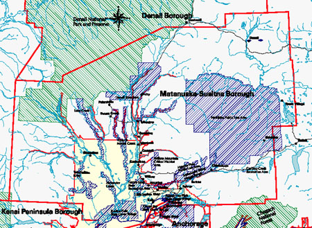
MSB Coastal Management Program (Fig. 4)
According to the existing MSB Coastal Management Program's enforceable and administrative policies, "development must be sensitive to the ecosystem in which it is located and incorporate mitigating measures into its design to minimize adverse impacts on that ecosystem.
"Recognizing that premature and scattered development needlessly degrades rivers, lakes and coastline open space, conflicts with other appropriate uses and causes extra public costs for public services, new development shall minimize its impact by consolidating development where possible." (MSB Coastal Management Plan, 1987)
The Coastal Management Program (CMP) recognizes the Knik/Matanuska River flood plains, Susitna and Little Susitna River floodplains, and the Point Mackenzie vegetated bluffs and coastline as geophysical hazard areas. These areas would have limited economic value and use due to development restrictions inherent in a geophysical hazard zone.
The CMP has designated areas within the borough as "areas meriting special attention." Criteria for designating a coastal AMSA include the following: (MSB Coastal Management Plan, 1987)
- Areas of unique, scarce, fragile or vulnerable natural habitat, cultural value, historical significance, or scenic importance;
- Areas of high natural productivity or essential habitat for living resources;
- Areas needed to protect, maintain, or replenish coastal land or resources, including coastal flood plains, aquifer recharge areas, beaches, and offshore sand deposits;
- Potential estuarine or marine sanctuaries.
Several coastal areas have already been recommended or established as AMSA's, including the Susitna Flats State Game Refuge, Goose Bay State Game Refuge, Palmer Hay Flats State Game Refuge, and the Knik/Matanuska River Floodplain. (MSB Coastal Management Plan, 1987)
The Importance of Wetlands
Coastal wetlands provide essential habitats for thousands of organisms. They also provide protection from severe storms, reduce the chance and severity of flooding, purify water by removing sediments and nutrients, prevent erosion, and supply a major source of food to a wide variety of fish and wildlife. Wetlands play a crucial role in regulating the movement of water within watersheds, as well as in the global water cycle. (http://www.dlwc.nsw.gov.au/care/wetlands/facts/importance.html)
Without wetlands the fish populations would decrease and both sport and commercial fishing would suffer the losses. Waterfowl hunters spend over $600 million annually in pursuit of wetland-dependent birds. A large percentage of this money goes directly to wetland habitat protection. Fifty million people spend an estimated $10 billion each year observing and photographing wetland-dependent wildlife. (http://www.tpwd.state.tx.us/wetlands/ecology/economics.htm)
There is a direct relationship between the environment and the economy because the economy is dependent upon the environment to provide resources and assimilate wastes. More than 40% of the fur and hide from wild game are harvested annually in the wetlands. In addition to providing the basis of hundreds of thousands of jobs, wetlands provide opportunities for scientists and educators to research.
Individuals use wetlands for hunting, fishing, personal water supply, and wood for fires. Since putting dollar values on many of these benefits is difficult, they are often overlooked. (http://www.tpwd.state.tx.us/wetlands/)
Wetlands help maintain the level of the water table and exert control on the hydraulic head. Climate control is another hydrologic function of wetlands. Many wetlands return over two-thirds of their annual water inputs to the atmosphere through evapotranspiration. Wetlands may also act to moderate temperature extremes in adjacent uplands. (http://www.fes.uwaterloo.ca/Research/Wetlands/Research.html)
Wetland processes play a role in the global cycles of carbon, nitrogen, and sulfur by transforming them and releasing them into the atmosphere. Storing carbon is an important function within the carbon cycle, particularly given observations of increasing levels of carbon dioxide in the atmosphere and concerns about global warming. When wetlands are preserved or restored, the wetlands act as a sink for carbon, since organic matter decomposition is stable or slowed. Wetland plants also reduce erosion as their roots hold the stream bank, shoreline, or coastline. Values associated with biological productivity of wetlands include: water quality, flood control, erosion control, community structure and wildlife support, recreation, aesthetics, and commercial benefits. (http://www.dlwc.nsw.gov.au/care/wetlands/facts/importance.html)
Wetland shape and size affect the wildlife community and the wetland's function as suitable habitat. Wetland size is particularly important for larger and wide-ranging animals that utilize wetlands for food and refuge, such as black bear or moose, since in many locations wetlands may be the only undeveloped and undisturbed areas remaining.
In 1980, the Alaska National Interest Lands Conservation Act (ANILCA) established more than 100 million acres of land into conservation system units (CSU's). CSU's include national parks, preserves and monuments, wildlife refuges, national conservation and recreations areas, wild and scenic rivers, and designated wilderness areas. The National Park Service, the U.S. Fish and Wildlife Service, the Bureau of Land Management, or the U.S. Forest Service manages these CSU's. (http://www.gov.state.ak.us/dgc/ANILCA/anilca.html)
The Alaska State Legislature has classified certain areas as being essential to the protection of fish and wildlife habitat. These areas are designated as a refuge, critical habitat area, or sanctuaries. Management of these special areas is the responsibility of the Alaska Department of Fish and Game (ADF&G). Legislation pertaining to these lands may be found in Alaska Statutes Title 16, Chapter 20. A special area permit is required for any habitat altering work, including any construction activity in a designated state refuge, critical habitat area, or sanctuary.
In the United States, the building of dikes and drainage ditches over the last two centuries has resulted in the loss of 30% of the nation's wetlands, 53% excluding Alaska. (Mitsch & Gosselink, 2000) According to a recent article in National Geographic, an estimated 50% of wetlands have been lost worldwide (Klesius, 2002). Wetlands are still under constant threat from agricultural/urban development, deforestation, human water use, and global climate change. Alaska has 174.7 million acres of wetland, occupying 43.3% of its 403,247,700 acres and contains about 63% of the nation's remaining wetlands.
Only 1% of Alaska's wetlands have been lost (Hudson, pers. com), though more are endangered or being destroyed daily in more populated areas of the state. The federal government has implemented a federal "no net loss" policy stating if wetlands are destroyed in one area, they need to be created in another for a "no net loss" of wetland acreage. This policy accents the critical importance of wetland habitats for our nation. The drawback to this federal policy is that destroying wetlands on the eastern seaboard cannot be justified by creating wetlands in Alaska or elsewhere, and visa versa. (Hudson, pers. com.)
State Game Refuges
A game refuge is a specially protected area that is managed by the ADF&G. There are certain rules/regulations that go into the protecting of a game refuge. There are different "levels" of access and protection. For example, some places may not let you use off-road vehicles while others will allow you, but with limits or requirements.
The primary value of a game refuge is to protect, maintain, enhance and manage the fish and wildlife populations and habitats to provide sustained opportunities for limited public and recreational use. Recent shifts in wildlife management policy would expand the focus from traditional efforts on managing game animals for fishing and hunting to nontraditional areas such as education, wildlife viewing and management of animals not thought of as game. Alaska has received $6.4 million in funding from Congress over the past two years to fund a new plan that shifts the focus towards "eco-tourism" from more traditional wildlife management. (Anchorage Daily News, 10/21/02)
The State of Alaska has already established three state game refuges within the MSB's coastal management plan boundaries (Fig. 3). These game refuges are owned by the state and managed by the ADF&G. They are designated as AMSA's by the MSB Coastal Management Plan. These refuges are the Goose Bay State Game Refuge, the Palmer Hay Flats State Game Refuge, and the Susitna Flats State Game Refuge. The lowland coastal marshes within these refuges are important resting and staging areas for waterfowl, and also provides for fishing, hunting, wildlife viewing, and other seasonal recreational opportunities.
The Goose Bay State Game Refuge (13,262 acres) is located in Upper Cook Inlet on the west side of Knik Arm across from Anchorage. It was created in 1975 by the Alaska State Legislature to ensure protection and adequate management of the area. The refuge features a wetlands embayment drained by the Goose Creek. Within its boundaries shrub habitat predominates. Fierce Knik Arm tides scour the outer shoreline of the refuge's eastern boundary. (http://www.state.ak.us/adfg/wildlife/region2/refuge2/goosebay.htm)
The Palmer Hay Flats Game Refuge (25,340 acres) is located north of the city of Anchorage, at the head of the Knik Arm in Cook Inlet. The refuge encompasses the mouth of the Knik and Matanuska Rivers. The Palmer Hay Flats is a 45 square mile complex of forest, tidal sloughs, rivers, lakes, wetlands and tidal flats. Marsh and bog communities are predominating there. Before the 1964 earthquake, the Palmer Hay Flats held a drier grassland habitat. There are tens of thousands of birds that live in the Palmer Hay Flats Game Refuge; it is a critical resting and staging area for spring and fall bird migration. It provides excellent fishing in Rabbit Slough and Wasilla Creek, and waterfowl hunting throughout the refuge during hunting season. The Alaska Legislature created the refuge in 1975. The Palmer Hay Flats refuge receives more usage than Susitna Flats and Goose Bay due to good access and close proximity to the Anchorage metropolitan area. (http://www.state.ak.us/adfg/wildlife/region2/refuge2/goosebay.htm)
The Susitna Flats State Game Refuge is located westward of Point MacKenzie and extends west to past Beluga River. It encompasses the majority of the Susitna River delta area along the upper Cook Inlet. It is the largest refuge in the MSB, consisting of about 301,950 acres, most of which are located within the MSB district boundaries. Susitna Flats is made up of 22% sub-tidal areas, 11% occasionally flooded salt marsh and meadow, and the remaining 67% is a combination of lakes, bogs, low shrub, and mixed lowland forest. The Susitna River drainage system is one of the major salmon producing areas in the state. The Alaska Legislature created the refuge in 1976. (MSB Coastal Management Plan, 1987)
The Plan
The most important challenge facing our coastal community is the expanding residential population in the MSB. As the residential population increases at a currently estimated 3.3% annually, which will be even more dramatic after the proposed Knik Arm crossing makes commuting to Anchorage faster, increasing development pressure will be put on coastal ecosystems.
We believe that wetlands and marine estuaries are the most productive and valuable ecosystems within the MSB, and protecting them is crucial for promoting continued tourism and sport opportunities within the area. In the 1990 reauthorization of the Coastal Zone Management Act (CZMA), wetlands are a top priority. (http://www.gov.state.ak.us/dgc/ACMPGrants/EGS/EGP9cats.htm)
Our plan is to increase the boundaries on the existing wildlife refuges within the borough, and to create wildlife corridors between the refuges to provide easy movement for animals to larger areas of habitat. The boundary increases would be mostly on state, federal, or borough owned lands, and trading out with publicly owned land will compensate the few private landowners in the area for land that is more feasible for development. The Great Land Trust, in Anchorage, Alaska, have been pursuing the development of conservation easements in the MSB with owners of land with high wildlife value. (DeLapp, pers. comm.)
Currently, the existing wildlife refuges within the MSB are managed by the ADF&G. We propose to expand the existing wildlife refuges to include geographically similar adjacent areas and follow natural boundaries rather than artificially imposed property lines. (See Fig. 3) Critical and sensitive habitat areas will be identified using NOAA "environmental sensitivity index" (ESI) maps. The management of the refuges would remain with Fish and Game, which is already funded for that purpose, and there would be little to no additional cost to managing more acreage. The Susitna Hay Flats Wildlife Refuge would remain essentially as it is. It covers the majority of the Susitna River drainage and would require little to no boundary adjustments. The Goose Bay Wildlife Refuge would be increased to encompass the remainder of the adjacent wetlands and follow more natural boundaries. The largest increase would be in the Palmer Hay Flats Wildlife Refuge. We would increase the boundaries to include the Knik/Matanuska River Floodplain, which is listed as an AMSA in the MSB Coastal Management Plan due to hazards. This boundary change will be directed to include all of the state and borough lands within the floodplain, and private in-holdings could be traded or purchased as they become available.
In addition to the natural boundary increases in the wildlife refuges, we would create wildlife corridors between all the designated AMSA's within the MSB. Wildlife corridors would be included as part of the refuge system, and would be a minimum of a mile to a mile and a half wide. The wildlife corridors would follow riparian zones and/or wetlands as much as possible to minimize impact on valuable development real estate. NOAA's environmental sensitive area maps will be used to delineate critical habitat areas to route the corridors. They would encompass state, federal, or borough lands wherever possible and will be placed along power line corridors and other existing right-of-ways.
We would petition the MSB Coastal Planning Department to zone areas adjacent to the refuges and wildlife corridors as buffer zones, with development geared towards leaving as much natural cover as is feasible to minimize impacts to the environment.
We believe that this plan is very cost effective, there is little added management costs associated with increasing the wildlife refuge boundaries. There will be little to no impact on development in the privately owned land within the borough. The management of each game refuge will remain with ADF&G, who will oversee the restrictions on use within each refuge. By protecting our valuable wetlands, we will protect the lifestyle that people move to the MSB to enjoy. Residential development will be constrained to more appropriate areas that minimize the damage to the environment. We do not wish to discourage planned community development to the area. Keeping a healthy environment is good for the economy, will increase the property values, and thus the tax and economic base of the area. Having abundant opportunities for increased wildlife viewing will tend to bring more tourism to the local area. Travel and tourism is the fastest growing industry in the state, (http://www.akrdc.org/issues/) and the MSB is located in an easily accessible area and should be primed to take full advantage of the tourism industry.
Existing roads, residential properties, and light industrial areas would not be included in the boundaries, except where totally necessary. Fair compensation for landowners would be mandated. The purpose of the proposal is to ensure adequate wild lands for the future, connectivity between ecosystems, and planned development within the MSB.
References
References: CD ROM's
Alaska in Maps-A Thematic Atlas (CD ROM) 1999. Alaska Geographic Alliance, Anchorage, AK
References: Maps
Research Planning Inc. 1994. Cook Inlet and Kenai Peninsula, Alaska Environmentally Sensitive Areas: Fall, Winter, Spring, Summer. Hazardous Materials Response and Assessment Division, NOAA (4 maps)
Matanuska Susitna Borough Coastal Management Program: Land ownership and general use map. Coastal habitat and resources map. Fish and wildlife habitat areas map. Matanuska Susitna Borough Planning Department, Palmer, AK (3 maps not dated)
References: Personal Communication
DeLapp, John. Cook Inlet Coastal Program, USFWS Ecological Services. 605 West Forth Avenue G-61, Anchorage, AK 99501 (907) 271-1799
Hudson, Ken. Coastal Coordinator & Code Compliance. Matanuska-Susitna Borough Planning Department, 350 E Dahlia Avenue, Palmer, Alaska 99645 (907) 745-9865
Reich, Robin. Project Manager, HDR Alaska, Inc., 2525 C Street, Suite 305, Anchorage, Alaska 99503 (907) 274-2000
Van Dongen, Marc. Port Director, Point MacKenzie Port Project, Matanuska-Susitna Borough, 350 East Dahlia Avenue, Palmer, Alaska 99645 (907) 745-4801
Whitney, John. NOAA Scientific Support Coordinator for Alaska, Anchorage, Alaska (907) 271-3593
References: Published
Alaska Department of Fish and Game, Marine Protected Areas Task Force. 2002. Marine Protected Areas in Alaska: Recommendations for a Public Process. Alaska Department of Fish and Game, Juneau, AK. 84 pages
Alaska Division of Governmental Coordination. 1998. Discover the Alaska Coastal Management Program. State of Alaska DGC, Juneau, AK 14 pages
Alaska Division of Governmental Coordination. 1998. Tour Alaska's Coast. State of Alaska DGC, Juneau, AK 84 pages
Alaska Division of Governmental Coordination. 1999. Introduction to the Alaska Coastal Management Program Guidebook 1. State of Alaska DGC, Juneau, AK. 96 pages
Bowlen, Scott. 2002. Marine protected areas concept eyed. Ketchikan Daily News: Nov. 16-17, 2002: A-1, A-3
Gay, Joel. 2002. Focus shifts in new wildlife plan. Anchorage Daily News: Oct 22, 2002: B1-2
HDR Alaska, Inc. 2002. Mat-Su Borough and Port of Anchorage investigate the Knik Arm commuter ferry. Knik Arm Ferry: Oct. 2002
Klesius, Michael. 2002. State of the planet, a global report card. National Geographic Vol. 202 No. 3 Sept. 2002: 102-115
Matanuska-Susitna Borough. 1987. Matanuska-Susitna Borough Coastal Management Plan. Palmer, AK: Matanuska-Susitna Borough Development Services Department. 111 pages
Matanuska-Susitna Borough. 1987. Appendices Matanuska-Susitna Borough Coastal Management Plan. Palmer, AK: Matanuska-Susitna Borough Development Services Department.
Mitsch, William, & Gosselink, James. 2000. Wetlands. Wiley & Sons, New York, NY. 920 pages
Woodby, Doug. 2002. Summary of Comments on "Marine Protected Areas in Alaska: Recommendations for a Public Process." Alaska Department of Fish and Game, Juneau, AK. 9 pages
References: Web
Alaska Coastal Program; homepage. http://www.alaskacoast.state.ak.us/ 11/29/02
Alaska Coastal Mangement Program; 9 national categories. http://www.gov.state.ak.us/dgc/ACMPGrants/EGS/EGP9cats.htm 11/29/02
Alaska Department of Fish & Game; refuges, critical habitat areas, and sanctuaries. http://www.state.ak.us/adfg/habitat/geninfo/refuges/refuges.htm 11/29/02
Alaska Native Resources; wetlands & watersheds. http://www.alaskanativeresources.com/ww.html 11/29/02
Alaska State Geo-spatial Data Clearinghouse; prevention and response subarea plan maps. http://www.asgdc.state.ak.us/maps/cplans/subareas.html#cook 11/29/02
American Oceans Campaign; April 12th 2002 testimony to appropriations committee. http://www.americanoceans.org/issues/testimony2.htm 11/29/02
Knik Arm Ferry; environmental assessment. http://www.knikarmferry.com/ 11/29/02
Matanuska Susitna Borough, Matanuska Susitna welcomes you. http://www.co.mat-su.ak.us/ 2/1/03
NOAA Coastal Services Center; Coastal zone information center digital library. http://www.csc.noaa.gov/CZIC 11/29/02
North Carolina State University; wetlands processes, functions, and values. http://h2osparc.wq.ncsu.edu/info/wetlands/funval.html 11/29/02
NSW Department of Land and Water Conservation; caring for our natural resources. http://www.dlwc.nsw.gov.au/care/wetlands/facts/importance.html 11/29/02
Pacific Fishery Management Council; fishery management EHF. http://www.pcouncil.org/salmon/salother/a14.html 11/29/02
Resource Development Council; issues. http://www.akrdc.org 11/29/02
Texas Parks & Wildlife; wetlands. http://www.tpwd.state.tx.us/wetlands/ 11/29/02
US Census Bureau; Matanuska-Susitna Borough. http://quickfacts.census.gov/qfd/states/02/02170.html 11/29/02
US Department of Agriculture, Economic Research Service; county level population data for Alaska. http://www.ers.usda.gov/Data/Population/PopList.asp?ST=AK 11/29/02
The Wetlands Research Centre; research programs, http://www.fes.uwaterloo.ca/Research/Wetlands/Research.html 11/29/02
Figures
Figure 1. MSB Population Graph 1970-2000
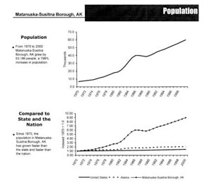
Population growth over time. (http://www.co.mat-su.ak.us/)
Figure 2. Value of Alaska Resource Exports 1997
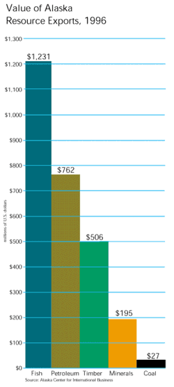
Fish, petroleum, timber, minerals, and coal in millions of dollars (Alaska in Maps, 1999)
Figure 3. State Game Refuges and Sanctuaries
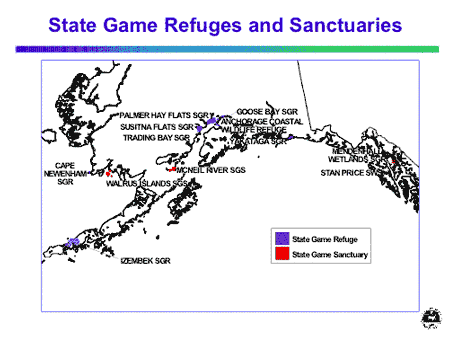
Map source: Alaska Department of Fish & Game
Figure 4. MSB Coastal Management Area Map
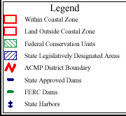
Alaska Division of Governmental Coordination (DGC) Coastal Zone Management Map
This page is HTML
4.01 validated. Last modified
07-Apr-2003. Contact ASG web coordinator.