
This paper was written as part of the 2003 Alaska Ocean Sciences Bowl high school competition. The conclusions in this report are solely those of the student authors.
Connecting the Southeastern Alaska Communities of the Northern Lynn Canal
Authors

Abstract
Providing transportation in Southeast Alaska has always been difficult. The remote geography and rugged geology have historically separated the communities of this region. Evolving economies and shifting populations have created a demand for more travel, commerce and trade opportunities. The outdated marine highway network and expensive air service can no longer satisfy the communities' demands. The time has come to revise Southeast's transportation network and consider the possibility of adding a ground link.
Our study is focused on the local area of the Northern Lynn Canal and Taiya Inlet. Juneau, Haines, and Skagway are the communities involved.
The three options being considered for transportation improvement are: updating the ferry system schedule, using high speed ferries, or constructing a highway along the east coast of Lynn Canal to link Juneau with Skagway.
The alternatives presented face geological hazards such as underwater reefs and avalanche zones. New construction may cause environmental impacts that must be mitigated or avoided. Relative costs and economic benefits need to be weighed. All of these factors come under intense public scrutiny.
After our study we concluded the fast ferry system would be most beneficial to implement in Southeast Alaska. The fast ferries have minimal environmental impact compared to highway construction. The two alternatives are almost equal in every other way considered. Estimated costs, after factoring economic growth, would be greater for high speed ferries, yet overall costs might be higher because of unavoidable road closures during avalanche season. Ultimately, environmental concerns are the pivotal point elevating high speed ferries to the preferred option.
Table of Contents
- Introduction
1.1 Background
1.2 Purpose - Alternatives to be Evaluated
2.1 Alternative 1- Improved Ferry Service
2.2 Alternative 2- High Speed Ferry Service
2.3 Alternative 3- East Lynn Canal Highway - Geological Considerations
3.1 Alternative 1- Improved Ferry Service & Alternative 2- High Speed Ferry Service
3.2 Alternative 3- East Lynn Canal Highway - Environmental Impacts
4.1 Alternative 1- Improved Ferry Service
4.2 Alternative 2- High Speed Ferry Service
4.3 Alternative 3- East Lynn Canal Highway - Economic Considerations
5.1 Alternative 1- Improve Existing Ferry Service
5.2 Alternative 2- High Speed Ferry Service
5.3 Alternative 3- East Lynn Canal Highway - Pleasing the Public
6.1 Alternative 1- Improve Existing Ferry Service
6.2 Alternative 2- High Speed Ferry Service
6.3 Alternative 3- East Lynn Canal Highway - Analysis
- Recommendation
- Bibliography
- Figures
1. Introduction
1.1 Background
The communities of Southeast Alaska share the common bond of transportation difficulties. Transportation between the communities is inconvenient at best and slow by modern standards. To travel from one town to another a citizen must choose between air and ferry travel.
Travel by ferry is time consuming, as well as expensive. For a citizen of Juneau to get onto the interstate road system they first must spend almost $200 and 7 hours on a ferry to Skagway.
Air travel in most of the towns of Southeast Alaska is limited to small aircraft and is not cheap for the users. For those not bringing a personal automobile on the trip air travel is a viable, yet still expensive, option. For those who need to bring an automobile, moving van, or very large cargo, however, the ferry system is the only available option.
The current ferry schedule makes traveling at leisure impossible. During the summer the ferries run a round trip daily and are generally at capacity or incapable of satisfying traffic demand. The winter schedule is even more restrictive as there is no daily rotation. Travelers need to make reservations and plan weeks in advance during the summer or alter the rest of their schedule to comply with the winter restrictions.
Transportation specifically connecting Juneau to the rest of the state has become politically charged as well. The majority of state legislators do not live in Juneau, so they must travel each year to attend session. They are left with the choice of either flying or taking the ferry. The high cost of flying means that few legislators will be able to get support from their constituency and visiting their district is less feasible. If the legislator wishes to bring their own vehicle to Juneau during session they incur the time investment required by ferry travel. The overall inconvenience and expense of the limited ferry service makes travel to and from the capital difficult. The very duty of a capital city is to service the rest of the state and the limited access to Juneau is clearly inhibiting that function.
In 1999, former Governor Tony Knowles discontinued funding for the Juneau Access study, effectively terminating any current examinations into the construction of a road. On December 17, 2002 Governor Frank Murkowski reopened funding on Juneau Access.
1.2 Purpose:
We have chosen to concentrate specifically on the transportation options between Haines, Skagway, and Juneau. This area is receiving the most political pressure to develop a better transportation system. This region is currently connected by the Alaska Marine Highway with outlets to the interstate highway system in Skagway and Haines. We aim to improve transportation in a manner that considers the four most integral facets of the problem: ecological impact, geological obstacles, economic costs and benefits, and public opinion.
Any major transportation change, whether marine or land based, will effect and be influenced by the traversed geography. The local terrain plays a large role in the viability of any alternative. The effect of a project on the local wildlife is something that must be seriously considered. Pristine environments are an important resource and as such must be recognized. How the transportation issue is resolved may permanently impact the roadless status.
The cost of a given alternative is an integral part which proposal to favor. Because funding for any major project must be negotiated, a project's cost is influential in whether it is favored.
Public support of a new transportation system is necessary. Without active public support a system will not be worth the costs, however low or high. Therefore it must be found before construction is begun whether the public supports the option.
We wish to find a solution that will satisfy the majority of the populations while at the same time have economic benefits that outweigh its costs and ecological impacts.
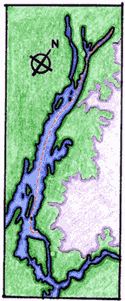
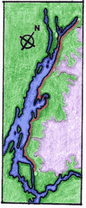
2. Alternatives to be Evaluated:
 |
|
Alternatives 1 & 2 |
|
 |
|
Alternative 3. Legend: Green represents land, blue represents water, the gray is the Juneau Ice Field and the yellow dots are Juneau, Haines and Skagway from south to north. The highway is red and the ferry route is orange. |
2.1 Alternative 1- Improved Ferry Service:
Department of Transportation (DOT) would update, adjust, and improve the already existing ferry schedule and service. Service would continue with the same vessels, facilities, and staff.
2.2 Alternative 2- High Speed Ferry Service:
Glacier Highway would be extended 8 km (5 mi) north to Sawmill Creek at Echo Cove. Mainline ferry service between Auke Bay and Haines/Skagway would be replaced by high speed ferry service between a new terminal at Sawmill Creek and Haines/Skagway.
2.3 Alternative 3- East Lynn Canal Highway:
A 105 km (65 mi) road would be constructed on the east side of Lynn Canal/Taiya Inlet between Skagway and Echo Cove (Juneau). The road would border around Berners Bay crossing over Antler River. A shuttle ferry would travel between Haines and a new terminal to be built on the Katzehin River delta. State operated ferry service in Lynn Canal between Juneau and Haines/Skagway would cease.
3. Geological Considerations:
The geological obstacles that each of the alternative face are summarized in this section.
3.1 Alternative 1– Improved Ferry Service & Alternative 2– High Speed Ferry Service:
3.1.1 Navigation Hazards:
As both Alternatives 1 and 2 are marine options that would follow the same paths, and will encounter the same geological obstacles. These are the various reefs and submerged rocks that are scattered throughout the Lynn Canal. Impediments have been identified and the routes realigned as result of long experience with marine transportation.
In an isolated incident on its maiden voyage in 1974 the MV Columbia collided with a rock and was forced to return to port. The collision was blamed on crew error, as it was a marked rock that the vessel struck. With the advanced detection systems the ships are outfitted with now, another such accident is deemed unlikely (Smith, 2002).
3.2 Alternative 3 – East Lynn Canal Highway:
3.2.1 Avalanche Safety:
The largest safety issue associated with the East Lynn Canal Highway is avalanche safety. A total of 58 avalanche paths intersect with the proposed road path (Fig. 1). While avalanches often stop before reaching the proposed road alignment, not all will. In some cases avalanches have been observed that swept over a proposed site and displaced debris up to a half mile offshore (JADEIS B, Snow Avalanche Report, 1997). Such an avalanche would be of a magnitude to push automobiles in its path into Lynn Canal if no avalanche mitigation measures are put into effect. Some large avalanches are expected to cross the road alignment each year.
Based on the standard avalanche hazard index (AHI) computations, the highway's calculated AHI of 346 rates above the 335 AHI value of Red Mountain Pass, Colorado, a road often cited as the most hazardous road in the United States. The AHI does not account for mitigation efforts, however, which if implemented could reduce AHI assessments to 10% or less of projected values. With application of periodic blasting, rigorous snowpack and weather observation, and construction of permanent avalanche control structures, the East Lynn Canal Highway could have an acceptable hazard index, below 40 AHI. It is estimated that implementing mitigation methods would require closure of the road several times each season, though rarely over a period exceeding three days (JADEIS, Affected Environment, 1997).
3.2.2 Geologic Obstructions:
Rock is exposed at different locations along the proposed highway route with blasting required in most cases where rock protrusions obstruct the alignment. The rocky profile of the southeastern coast would complicate construction efforts. The most technically difficult section of land to build on runs along the steep terrain of Taiya Inlet. Extensive use of cuts and fills would be required for roadwork, and partial cuts and structures to minimize the visual impact.
3.2.3 Rivers and Streams:
The proposed road alignment crosses a total of 62 waterways, five of which are classified as navigable by federal standards. The designs of crossings over these rivers would have to satisfy major bridge construction parameters. There are also limitations to construction methods for major bridges as well, all of which would increase the cost of crossings. These five large rivers also present a flooding hazard, as all have potential 100-year flood cycles.
3.2.4 Wetlands:
A large section of the proposed road passes over ground classified as wetlands or special aquatic sites. The unstable nature of this terrain requires extra support for the foundations of road structures. This would entail the excavation or filling of areas where the wetlands and special aquatic sites are below the Mean High Water line. Constructing this road is estimated to require the excavation or filling of approximately 137.6 acres of wetlands. Realignments that would avoid these wetlands have been considered, yet were determined to be unfeasible (JADEIS, Wetlands Technical Report, 1997). In addition to major construction difficulties, the considered alignment shifts also had conflicts with natural resources other than wetlands.
3.2.5 Seismic Activity:
Another concern is that of seismic activity. Southeast Alaska has a history of earthquakes. Earthquakes of a magnitude greater than 6.0 could occur in the Lynn Canal area. A tremor that strong could cause soil liquefaction and ground displacement, which would devastate portions of the road and be hazardous to vehicles traveling it (JADEIS, Environmental Consequences, 1997). A tremor also aggravates the likelihood of other natural disasters, such as an avalanche, landslide, tsunami, or flood. Underwater landslides can create massive waves which would be dangerous for both land and marine options.
4. Environmental Impacts
Alternatives were evaluated for potential to impact Steller sea lions, bald eagles, other wildlife, wetlands, and anadromous fish streams. These impacts, if any, are summarized below.
4.1 Alternative 1- Improve Existing Ferry Service:
4.1.1 Wetland Impacts and Mitigation:
If the Auke Bay ferry terminal is expanded to accommodate more than one ferry at a time, wetlands will be impacted only minimally. Avoiding wetland areas for construction activities will make the impacts negligible.
4.2 Alternative 2- High Speed Ferry Service:
4.2.1 Steller Sea Lion and Mitigation:
The high speed ferries will travel the same routes as the existing mainline ferries and will not disturb any sea lion critical habitat. The higher speeds of the ferries will increase the rate of sea lion/ferry collision but this rate will continue to be negligible.
4.2.2 Environmental Impacts:
This alternative would require construction of a 6.5 km road north to Echo Cove which would pass two eagle nests. The road would be more than 350 m from these nests. The terminal would be more than 600 m from any bald eagle nests. Human use of the terminal and the grounds around it could result in some minor disturbance of bald eagles. The construction of the terminal and road would be scheduled for times of year when the bald eagle nests are unoccupied and activity near nests would be limited.
4.3 Alternative 3- East Lynn Canal Highway:
4.3.1 Steller Sea Lions and Mitigation:
Construction and continuing use of the highway may disturb the Steller sea lions on their haulouts. Parts of the highway corridor must be cleared by blasting. Noise from blasting has the potential to harass the animals on the haulouts. The noise level threshold for sea lions is believed to be around 1,000 to 30,000 Hz. The dBA (decibel adjusted) at the haulout site was measured at 47 dBA. Blasting near the haulout would cause air blast and ground vibration. Smaller 20 lb charges will be used so the vibration produced will be less than half the estimated threshold of sea lions (0.1 inches per second). At these levels there is no significant expected disturbance to sea lions from blasting.
The continuing disturbance to sea lions is thought to be very low. It would be difficult for a human to get to the haulout from the road so harassment will be minimal. The continuing traffic on the road is not expected to be loud enough to disturb the animals on the haulout.
4.3.2 Bald Eagles and Mitigation:
Bald eagles are protected under the 1940 Bald Eagle Protection Act. This act prohibits any disturbance of bald eagles. There are 78 bald eagle nests on the east side of Lynn Canal along the East Lynn Canal Highway alignment. Of the 78 bald eagle nests in the affected corridor, 66 would be more than 100 m from the road. The mitigation policy is to require 100m minimum distance between construction activity and a nest, unless other action is taken such as barriers or leave sufficient vegetation to keep nests safe and productive. Seven nests are less than 100 m from the road and five nests are less than 50m.
Blasting activities on the highway must be 800 m or more away from the nests. Bald eagle nests are occupied from March through August, if a nest is not chosen by May 31, then activities can continue without fear of disturbance.
Other mitigation proposals are to send out a bald eagle expert in advance of construction to ascertain if the nests are being used that season. If not, then construction could continue closer than 800 m from nests. Another proposal would be applying to U.S. Fish and Wildlife Service for permission to place a structure over each nest to prevent use of it.
4.3.3 Other Wildlife and Mitigation:
Other wildlife potentially affected by alternative 3 would be brown bear, black bear, marmot, mountain goat, and moose. The environment that they live in, old-growth fringe, beach fringe, and estuary fringe, would also be affected by the East Lynn Canal Highway.
4.3.3.1 Human Consumptive Use:
Construction of the East Lynn Canal Highway would result in a short term increase of wildlife availability. The long-term wildlife availability, however, could be decreased due to an anticipated over-harvest.
4.3.3.2 Large Mammal Habitat Disturbance:
There are a total of 148,593 acres in the project area, all presently providing habitat. The four main indicator species used to indicate changes in habitat quality or quantity are brown bear, black bear, marmot, and mountain goats.
4.3.3.3 Environmental Impacts and Mitigation:
The construction of an East Lynn Canal Highway would result in three types of impacts: permanent loss of habitat from clearing, grading, and surfacing; permanent displacement of animals from lost habitat; and disturbance of animals in surrounding areas. Use of the highway would result in three types of impacts: increased wildlife mortality from vehicle collisions; disturbance of animals in surrounding habitat areas; probable creation of a barrier potentially blocking movement of animals across either side of the road.
4.3.4 Wetland Impacts and Mitigation:
The East Lynn Canal Highway alternative contains 28,571 acres of wetland and special aquatic sites regulated under the Clean Water Act. Special aquatic sites include: sanctuary and refuges, mudflats, wetlands, vegetated shallows, coral reefs, and riffle pool complexes.
4.3.4.1 Environmental Impacts and Mitigation:
The construction of the east Lynn Canal highway would require filling of 20.1 hectares of wetlands, 1.1 hectares of estuarine wetlands, and 34.5 hectares of special aquatic sites below mean high water. At the Katzehin River, avoidance of the wild and scenic river management area restricts the alignment to a corridor requiring the filling of wetlands. The preferred bridge crossing has been shifted downstream approximately 150 m at the north end of the bridge to avoid vegetated shallow at the mouth of the stream.
4.3.5 Anadromous Fish and Stream Habitat:
4.3.5.1 Affected Fish Species and Habitats and Mitigation:
There are five species of salmon, two species of trout, and the eulachon aquatic species that may be adversely affected by this alternative. The affected habitats of these fish species are spawning habitat and rearing habitat.
4.3.5.2 Environmental Impacts and Mitigation:
Along the East Lynn Canal route, there are 63 streams, 11 of which support anadromous fish. Highway construction would cross several anadromous fish streams. The crossing structures (bridges and culverts), if installed correctly, should mitigate any impacts. Bridges over 50 feet and up to 145 feet require use of piling in the stream. Depending on placement techniques, pilings generate a higher impact on the stream than a single span bridge. Installing culverts has little impact if properly installed just below the streambed and during a period when no eggs are present.
5. Economic Considerations:
The alternatives were evaluated for cost, impacts on economies, and resource access.
5.1 Alternative 1- Improve Existing Ferry Service:
5.1.1 Cost:
In 1994 the annual maintenance of the Lynn Canal ferry service and operating cost was estimated at approximately $8.4 million. This amount will not change with no change to the ferry system. Annually $6.5 million of that figure is recovered from ticket sales. With improved convenience and increased appeal to the users, this amount is likely to increase. These factors will produce a net expenditure that is less than the cost of present ferry service (JADEIS, 1997). On a 20-year outlook, the cost will reach that of the road with a traffic count of 750 vehicles per day. At 250 vehicles per day, the cost will be the same as the high speed ferries (Fig. 2).
5.1.2 Resource Access:
Timber harvest in Southeast Alaska will not be affected by the implementation of this alternative (JADEIS C, 1997).
5.1.3 Land Ownership:
Since the ferry system will not be physically changed, no new land will need to be established. Land acquisition would not present a conflict.
5.2 Alternative 2- High Speed Ferry:
5.2.1 Cost:
The total cost of this alternative would depend on the amount of traffic as funds can be recovered from ticket sales. Average annual operational cost would come to just under $12 million and at present traffic levels will cost approximately $200 million.
5.2.2 Resource Access:
The high speed ferries would give Haines and Skagway residents a chance to have transport to the Kensington and Jualin mines creating employment opportunities and promoting the development of these mines.
5.2.3 Economy:
Faster ferries would encourage tourists to travel more. The money spent by nonresidents would be enough to support 10-60 new jobs in the tourism industry in Haines, Skagway, and Juneau. The recirculation of visitor money would support 5-10 new jobs. The Alaska Marine Highway System (AMHS) would be able to support up to 145 new jobs (JADEIS C, 1997).
5.3 Alternative 3- East Lynn Canal Highway:
5.3.1 Cost:
The total cost of construction comes out to be $232 million overall. The federal government is responsible for 90% of that construction fee, leaving $23.2 million up to the State of Alaska. Annual operating costs are estimated at approximately $4.5 million dollars.
Tourism spending in Haines is expected to increase as a result of highway construction. In Haines $1.1 million could be generated by the visitors. An additional 15 jobs or approximately 45 seasonal jobs would be created (McDowell Group, 1997).
5.3.2 Resource Access:
The Goldbelt land contains commercial timber, but there are no current plans to harvest it. The harvest of the newly accessible timber would become a part of the construction process. The boards per acre in this area range from minimal to as much as 30,000. (JADEIS C, Land Use and Coastal Zones Technical Report, 1997).
The road on the east side of Lynn Canal will run by the Kensington and Jualin mines. This would facilitate the development of these two mines. Direct road access would allow residents of Haines and Skagway to work at the mines. Presently, transportation is only offered to Juneau residents, but with the road, workers from other communities would have access as well. The development of this highway (shuttle ferry service for residents of Haines) would allow workers to commute instead of arranging special transportation.
5.3.3 Land Ownership:
Twenty-eight miles of the land intended for construction is owned by the Goldbelt Corporation. Access to their land around Echo Cove would be facilitated by the construction of a road. Tourism, transportation-related activities, and recreation would increase in Echo Cove.
5.3.4 Economy:
This alternative would replace the ferry system between Juneau, Haines, and Skagway. Although AMHS is not a profiting corporation, there would be a loss of jobs with the discontinuation of this Lynn Canal circuit.
Juneau's larger size affords it greater resources. Many residents from Haines and Skagway travel to Juneau for business, pleasure, shopping, and medical services. Implementation of this alternative would decrease travel expense for Haines and Skagway residents. This access to necessary resources improves quality of life for Haines and Skagway residents. The Juneau economy would also benefit from increased revenue from sales and sales tax. Juneau residents would travel more often to Haines and Skagway for recreational purposes and are expected to support the economies in those communities.
5.3.5 Recreation Access:
There are many popular hunting areas along the proposed highway route. Increased trapping and hunting activities may interfere with hikers or cross country skiers. While local poaching already occurs, it is expected to become a more serious problem with construction of an East Lynn Canal highway (JADEIS C, 1997).
Construction of this highway would provide more recreational opportunities for snowmobiles. The increased activity will necessitate increased public service capabilities from all three communities.
6.0 Pleasing the Public:
A successful transportation solution will satisfy the transportation needs of the people who use it. In order to do this, the Juneau access alternative selected must be: economical to the users; within the State of Alaska's budget allocated for transportation improvement; convenient to use; a substantial improvement over the present Juneau access options; a source of jobs for Alaskans during the construction stage and a source of jobs extending indefinitely for maintenance and operation.
6.1 Alternative 1- Improve Existing Ferry Service:
6.1.1 Economical to the Users:
Presently a ticket for one passenger from Juneau to Haines costs $28 and $35 to Skagway. A ticket for one passenger with one vehicle (up to 10 ft) from Juneau to Haines is $144 and $173 to Skagway (AMHS, 2002). The cost discriminates against residents who cannot afford to purchase a ferry ticket, preventing them access to Juneau or Outside (McDowell, 1994).
6.1.2 Affordable to the State:
The Alaska Marine Highway is presently maintained by the State of Alaska for at the cost of $8.5 million per year. The initial cost of researching, revising, and improving schedules would amount to less than $1 million. Over the long term, improved efficiency will save the State money due to increased patronage (JADEIS, 1997).
6.1.3 User Convenience:
Schedules will be more accommodating to demand and ferries will not run over capacity.
6.1.4 Local Construction Jobs:
Improving ferry service will provide research, public relations, and design jobs.
6.1.5 Service Consistency:
Consistency will be increased with improved schedules. More than half of Haines households surveyed in 1994 said that they had been forced to cancel a ferry trip because of schedule or reservations difficulties. A third of Juneau residents and 40% of Skagway residents reported canceling trips for the same reasons (McDowell, 1994). With the improved schedule, the ferry system will be more equipped to handle summer peak demand and fewer passengers will be forced to forgo their travel.
6.1.6 Scenic Value:
This alternative does not change the existing system in its physical form, therefore the impact on the environment will not be measurably increased or decreased. In our surveys, many people responded positively to perceptions about marine travel because it is not associated with environmental impacts.
6.1.7 Safety:
Safety will be increased with less crowded ferries, though this increase will be small. The historic precedence of ferry service adds to public trust of marine travel (Fig. 3).
6.2 Alternative 2- High Speed Ferry Service:
6.2.1 Economical to the Users:
Alaska Marine Highway System would continue to use the current price scale with the new high speed ferries. Users would save only in time with faster travel and more flexible schedules.
6.2.2 Affordable to the State:
Because the high speed ferries use more fuel than the ferries in use now, they incur a greater operating cost. This discrepancy in fuel cost, however, is balanced by the smaller crew required to operate the ferries (Smith, 2002). The annual maintenance and operation cost to the state would be close to $12 million (Glosten, 2000).
6.2.3 User Convenience:
Like Alternative 1, user convenience would be increased because of better scheduling. The addition of fast ferry service would decrease travel time and save the consumers money. Smaller, quicker ships would allow for more frequent and flexible runs (JADEIS, 1994).
6.2.4 Local Construction Jobs:
No local residents would be employed in building the fast ferries because they would likely be constructed by an out of state shipyard. The construction of a new terminal at Sawmill Creek would create local construction and design jobs.
The possibility of expansion of Allen Marine in Sitka would greatly increase the local employment opportunity. Although Allen Marine is not currently large enough to support the construction of the ships necessary for ferry service, they would receive a lot of business if the State of Alaska contracted them to build and maintain the fleet. The contract of the fleet would provide Allen Marine with the financial capability to expand their facilities. The expanded shipyard would allow Allen Marine to accept larger contracts and increase their business.
6.2.5 Long Term Maintenance Jobs:
The implementation of high speed ferry service would result in fewer jobs as the high speed ferries use a smaller number of crew.
6.2.6 Service Consistency:
The expanded schedule afforded by using smaller, quicker ferries would mean more travel opportunity for the users. Passengers scheduling reservations would not need to worry about ferries being sold out during peak summer times. Ferries are capable of running even in dense fog that prevents airplanes from flying. More extreme weather could halt ferry service.
6.2.7 Scenic Value:
Most of the environmental damage incurred by the marine options would occur with the construction of a new terminal at Echo Cove. This would involve the extension of Glacier Highway 8 kilometers/5 miles north and the construction of a ferry terminal at Echo Cove. There is already a dirt road along that alignment, so further damage from paving will not be significant. The construction of a new ferry terminal would mean clearing land and disturbing wildlife in the Echo Cove area. The operation of the ferries themselves, however, leaves comparatively minimal impacts on the environment.
6.2.8 Safety:
High speed ferry travel is not inherently more dangerous but the smaller size of the boats and staff may mean fewer safety services. The fast ferries will carry fewer passengers and therefore fewer staff. This means that there may be fewer trained medical personnel on board. The smaller ferries would also be more affected by rough seas. While this would not make travel more dangerous, it may cause more passengers to lose their cafeteria lunches.
6.3 Alternative 3- East Lynn Canal Highway:
6.3.1 Economical to the User:
Travelers driving on the East Lynn Canal Highway to Haines would need to purchase a shuttle ferry ticket. The estimated price of this would be $15. In addition, travelers would be driving a total of 80 miles to Haines or 100 to Skagway (JADEIS, 1997). At an estimated price of $1.70 per gallon and a fuel efficiency of 20 miles to the gallon, drivers would spend $6.80 to drive to Haines and $8.50 to Skagway. Users will be free to travel at their convenience and there will be a significant decrease in travel time contributing to user savings.
6.3.2 Affordable to the State:
At community meetings and surveys, many people complained that construction of a highway would be at too great a cost (Fig 3). The federal government would contribute 90% of the construction fee and the remaining 10% would be covered by state matching funds. A feasibility study compared a toll road option to a toll-free road and found that over the long term, the toll-free option was more feasible.
6.3.3 User Convenience:
Construction of an East Lynn Canal Highway will allow travelers to drive at their convenience. Waiting for ferry service or traveling at odd hours of the day would not be necessary. Reservations would not be necessary making last minute travel possible.
6.3.4 Local Construction Jobs:
Over the 11-year estimated construction period, 150 jobs would be created in Juneau, Haines, and Skagway. These jobs would be in the field of heavy construction and be compensated with a $56,000 per year salary. This would provide not only employment for Southeast residents but also an opportunity for training and experience (JADEIS, 1997).
6.3.5 Long Term Maintenance Jobs:
The road runs through many avalanche zones and winter snow is certain in Southeast Alaska. Therefore a fleet of plows and snow-clearing machinery would need to be kept by DOT&PF for the specific purpose of keeping this road operable. Seasonal jobs would be created for the plowing and maintenance of this highway. Frequent repaving and repair would be necessary to even out frost heaves and wash outs creating more opportunity for employment.
6.3.6 Service Consistency:
Although this highway would be theoretically open all hours of every day of the year, the likelihood of closure at some times due to inclement weather conditions is certain. The highway runs through a string of avalanche zones similar to the Seward Highway. The Seward Highway is closed frequently during the spring thaw because of avalanches and statistically has the most vehicle accidents of any highway in the state. The East Lynn Canal Highway would meet with similar difficulties and therefore should not be advertised as a completely reliable year round access corridor (The Mile Post, 2002).
The highway does not directly connect to Haines creating a public objection to this alternative (Fig. 3).
6.3.7 Scenic Value:
In community meetings and surveys, adverse environmental impacts were the second most common complaint about the East Lynn Canal Highway alternative (McDowell, 1994). Presently, no construction is visible along the coast of the Inside Passage and it has great scenic value (Alaska.com, 2002).
6.3.8 Safety:
This road will have a very high incidence of accidents because of the danger of avalanches, slippery conditions, rock slide areas, and wildlife collisions. A road of this size and remoteness would be difficult to maintain in optimum driving condition for all seasons of the year. An optimistic estimation of accidents is 2.16 per million vehicle miles traveled. In fact, this highway could greatly increase the annual fatality rate associate with travel between Juneau and Haines/Skagway. Casualties, injuries, and accidents impose increased demands on public safety services that have not been realistically portrayed in the analysis (Lochner, 1994).
7. Analysis:
After reviewing the facts of this study a clear solution still does not emerge. Each alternative poses benefits superior to the others, while each alternative still has its obstacles and shortfalls. Southeast Alaska's transportation situation will only be solved when we analyze the data in an unbiased and logical manner and take action accordingly. All factors should be given weight based on their overall contributions to the desired outcome.
Because the problem at hand reaches far into the daily lives and pockets of every citizen, public opinion and economics should be top priority in this decision. If an alternative does not solve the social transportation problem then we will not be able to solve the problem. Public support, costs, and economic benefits can make or break any proposed transportation project.
The feasibility of a project, in terms of the land or water it traverses, greatly affects the viability of a transportation design. An idea may be great in solving every issue brought up, but if the design is not possible or would be incredibly difficult then it need not be considered. Also, the effect of the transportation method on the surrounding wildlife must be given weight.
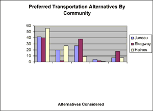
In polls conducted by the McDowell group in 1994 it has been shown that the majority of the population supports Alternative 3, the East Lynn Canal Highway. This support comes mostly from the Juneau and Skagway populations. Haines residents, however, are upset by the proposition of a road as it is their feeling that it would cut them out of the economy. The difference in support between the highway and Alternative 2, high speed ferries, is small. Fast ferries have a social benefit over the highway in that they garner strong support from Haines and would not upset Juneau or Skagway. High speed ferries benefit all community members equally and do not discriminate against residents without vehicles.
On a 20 year outlook the East Lynn Canal Highway costs more than a fast ferry if current traffic stays the same, it is less expensive however than the conventional ferry system. For the costs of the fast ferries and the highway to be equal traffic would have to reach 1000 vehicles per day on average. The higher cost of the road is however lessened by the fact that the federal government gives the state 90% of their road construction funding. Also, studies (Brock, 1997) have shown that the highway brings significant economic benefits to Southeast Alaska. The town of Haines, which cites loss in economy as an argument against the highway, would see a significant increase in jobs and tourist spending.
As a result of the infrastructure for the ferry system being in place for a long time, the geological obstacles faced by ferry transports are known and avoided. With the construction of fast ferries no new obstacles are expected. The construction of an East Lynn Canal Highway would face many challenges and obstructions. The operation of the road would be subject to several approximately three day closures each year due to avalanches.
Alternative 1, improved ferry service, can be eliminated simply because it does not solve any of the issues identified. It would not allow for greater traveler convenience or for a greater capacity of travelers. Overall, East Lynn Canal Highway and the high speed ferry have almost equal community support with a 51:49 vote in favor of the ferry (2000 advisory vote). Economically the road is more beneficial and its costs could be slightly lower to the State if federal matching funds are received. Cost is outweighed by the fact that the road would face many construction challenges and would close for maintenance through the winter avalanche season. This leaves us with two options that seem to be almost equal in benefits and costs.
What sets one apart from the other is the environmental effects. By far the East Lynn Canal Highway has more detrimental affects to the environment then the high speed ferry system. While the fast ferries avoid bald eagle nests; the highway will displace a large number of nests. While the highway will cut through several river deltas and wetland areas impacting pristine wildlife; the high speed ferries will require a comparatively small amount of construction. In order to build the highway 872 acres of woods must be clear cut only the sites for the new terminals would need deforestation in the high speed ferry plan.
8. Recommendation:
After these considerations our team must recommend the state invest in a high speed ferry system plan. The plan for an East Lynn Canal Highway comes at too high of a cost environmentally to be justified by its slight economic and social advantage over high speed ferries. In order to protect and preserve the environmental treasure we have in Southeast Alaska we must not build a highway. The high speed ferry system will meet the transportation needs while remaining socially and environmentally conscientious.
9. Bibliography:
Alaska Department of Transportation & Public Facilities, Southeast Division. Juneau Access Draft Environmental Impact Statement (JADEIS), June 1997.
Alaska Marine Highway System, Fall/Winter/Spring 2002/2003 Official Schedule, Alaska Department of Transportation & Public Facilities, Alaska Marine Highway System. Adventure Media International, 2002.
City and Borough of Juneau, Kensington Mine Project Recommendation Document, http://www.juneau.lib.ak.us/cdd/Kensington/.
Faris, Tamra. NOAA NMFS Marine Biologist. Personal Interview. 12, December 2002.
Glosten Associates, Inc. AMHS Vessel Suitability Study Task 4 Report, October 2000.
Goldbelt Corporation Website, http://www.goldbelt.com/land_re/Echo_Cove.html, 2002.
H. W. Lochner, Inc. Juneau Access Improvements User Benefit Analysis, Juneau Access Improvements Reconnaissance Engineering Report, May 4, 1994.
McDowell Group, Juneau Access Household Survey, August 1994.
Smith, Greg, Naval Architect. Personal Interview. 12, December 2002.
The Mile Post, 2002, http://www.themilepost.com/PDF_files/Seward_Hwy_02.pdf.
Unruh, Leon. "Highways: The way to really see Alaska." Alaska.com. http://www.alaska.com/akcom/southcentral/accommo_trans/story/1221185p-785932c.html.
Figures
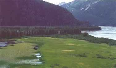
Figure 1. A stretch of the East Lynn Canal Alignment.

Yellow dots denote an avalanche path and its corresponding number in the Juneau Access Draft Environmental Impact Statement.
Figure 2. This graph shows the relation between average daily traffic and the 20 year life cycle cost of each option.
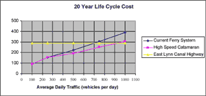
Figure 3. Graphic representation of public sentiment in affected communities as expressed in a 1994 household survey conducted by McDowell Group.
This page is HTML
4.01 validated. Last modified
18-Apr-2003. Contact ASG web coordinator.